
Admiralty inlet slowdown
Admiralty Inlet Voluntary Vessel Slowdown
A collaborative effort to reduce underwater noise for endangered whales
Since 2022, Quiet Sound has implement a seasonal voluntary slowdown in Admiralty Inlet and north Puget Sound in the fall and winter months when SRKW typically visit the area. When safe and operationally feasible, large commercial vessels are encouraged to reduce their speeds. By slowing down a few knots, vessels can significantly reduce their underwater noise. With quieter waters, orcas are better able to hunt and communicate with their pod. Past Quiet Sound slowdowns have reduced underwater noise by 12-50%.
The 2026-27 Voluntary Vessel Slowdown Begins September 4, 2026
The 2026-27 voluntary vessel slowdown will be in effect from 0001 PST September 4, 2026 through 2359 PST January 31*, 2027.
*Exact end date will be based on SRKW presence.
2026-27 Voluntary Vessel Slowdown Parameters
Dates: September 4, 2026 – January 31*, 2027
Speed:
When it is safe and operationally feasible, ships are encouraged to transit the slowdown area at or below the following speeds through water:
-
- 14.5 knots – speed through water or less for vehicle carriers, cruise ships, and container vessels
- 11.0 knots – speed through water or less for general cargo, bulkers and tankers
The slowdown does not include recommendations for fishing or recreational vessels.
Location: Admiralty Inlet and North Puget Sound
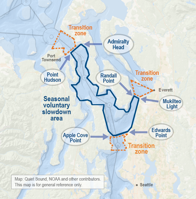
The voluntary vessel slowdown takes place in the inbound and outbound lanes of the shipping lanes within these boundaries:
-
- Northwest boundary of the slowdown: A line drawn between Point Hudson (48.117264, -122.748907) and Admiralty Head (48.15217, -122.679503)
- Northeast boundary of the slowdown: A line drawn between Randall Point (47.983237, -122.352871) and the Mukilteo Lighthouse (47.948181, -122.308043)
- Southern boundary of the slowdown: A line draw between Apple Cove Point (47.815535, -122.480885) and Edwards Point (47.803340, -122.394924)
The slowdown area excludes Hood Canal.
For a full-size map of the slowdown, click here.
Check out the Admiralty Inlet slowdown in the World Shipping Council’s Whale Chart, alongside other whale protection measures around the globe.

Measuring the slowdown’s impact
Quiet Sound evaluates the following metrics:
- Vessel Participation: We use participation data collected by the Puget Sound Pilots to quantify the number of transits that reduced their speed.
- Vessel Speed Reduction: We use AIS data from the Marine Exchange of Puget Sound, corrected for STW, to quantify the number of transits whose mean speed was below the target for their vessel class.
- Acoustic Benefit: In the first three slowdown seasons, Quiet Sound worked with SMRU Consulting to deploy a hydrophone in Useless Bay to measure changes in underwater noise during the slowdown and a baseline period for comparison. In 2025 , we began leveraging prior data sets to statistically estimate the noise reduction of the slowdown.
- SRKW Presence: Quiet Sound contracts with Orca Network to support increased human capacity for visual sightings during the slowdown. We also collate other SRKW detections sent to the Whale Report Alert System.
Sign up for our newsletter to receive bi-weekly updates on participation and whale presence while the slowdown is in effect.
Read results of our past slowdown seasons here:
- 2022-23 Slowdown Trial Report
- 2023-24 Slowdown Results (Executive Summary; Full Report)
- 2024-25 Slowdown Results (Executive Summary; Full Report)
- 2025-26 Slowdown Results (Executive Summary; Full Report)
Information for Vessel Owners, Operators, and Fleet Managers
Fleet Participation Reports
Quiet Sound provides fleet operations managers regular updates on their fleet’s participation throughout the slowdown and after the slowdown has concluded. If you would like to receive this information, please complete this Intent to Participate form.
Whale Awareness
Quiet Sound encourages mariners to sign up for the Whale Report Alert System (WRAS) to receive alerts when you are within 10 nm of a verified whale sighting. Fleet operations centers can also select geographic areas for alerts. If you belong to a government or professional marine organization or are a pilot or member of the crew of a ship, please contact the WRAS Project Manager at WRAS@ocean.org to request access to WRAS (available on desktop, mobile, and on pilot PPUs).
Mariners can also take the “Whales in our Waters” online training to learn how to identify and share waterways with whales. It is administered by the Vancouver Fraser Port Authority’s ECHO program and provides a certificate for each person who completes the 60-75 minute tutorial.
Recognition
Quiet Sound provides all participating companies with a Recognition Certificate featuring artwork from Tulalip artist, Ty Juvinel. We also provide companies with final slowdown participation reports, which can be used in sustainability reporting and certifications, such as Green Marine.
Quiet Sound nominates exemplary participants for regional awards, such as the Port of Seattle Sustainable Century Award and the Northwest Seaport Alliance North Star Award. In 2025, MSC was selected as the winner of the Environmental Stewardship North Star Award for their participation in our voluntary slowdown and engagement in other noise reduction and vessel impact mitigation strategies to protect biodiversity. In 2026, Carnival Corporation was selected as a winner of a Sustainable Century Award for their industry-leading participation in the slowdown.


Pictured: Sara Adams (Quiet Sound) with Matthew Harris (MSC) at the 2025 North Star Awards reception.
Pictured left to right: Paul McClelland (Holland America Line), Anthony Auriemma (Carnival Corp), Commissioner Sam Cho, Rachel Aronson, Sara Adams at the 2026 Sustainable Century Award luncheon. Credit: Port of Seattle.
Thank you to Slowdown Participants!
Contact our team to be recognized for your participation in the slowdown!
Hapag-Lloyd
Hyundai Glovis
MOL (Americas), LLC
OOCL
Pacific Basin Shipping
Swire Shipping US Inc.
Yang Ming Lines
ONE
Reporting Whale Sightings
Mariners and members of the public can report whale sightings through:
- The U.S. Coast Guard Cetacean Desk at (206) 217-ORCA (6722) or in the Puget Sound VTS designated traffic channels (5A, 14);
- Orca Network, www.orcanetwork.org/report-sightings, sightings@orcanetwork.org or 866-ORCANET (672-2638);
- Mariners in Canadian-managed waters may report sightings to the Canadian Coast Guard Marine Mammal Desk at (833) 339-1020.
acknowledgements
Quiet Sound recognizes the essential contributions of the Leadership Committee and working groups who provided input on the seasonal slowdowns. We also thank the ECHO program for their continued mentorship and partnership in operationalizing these programs.
Puget Sound Pilots play a pivotal role in the on-water success of this effort. The Marine Exchange of Puget Sound provides AIS data and shares information with the maritime industry. The Pacific Merchant Shipping Association helps shape parameters and supports communication with shipping companies. Orca Network provides real-time SRKW sightings information during the slowdown. SMRU Consulting supports analysis of slowdown data. The U.S. Coast Guard Sector Puget Sound communicates slowdown parameters to mariners.
We thank all the tribal governments who considered our proposal to put forward this program for vessels traveling through their usual and accustomed fishing areas.
Quiet Sound gratefully acknowledges all the partners who are working to provide Washington mariners with real-time whale locations, including: Ocean Wise, Orca Network, Acartia, Conserve.io, and all the members of the public who report sightings.
The slowdown would not be possible without the support of Quiet Sound funders: AltaGas, National Fish and Wildlife Foundation with support from the US Department of Defense and National Oceanic and Atmospheric Administration, Northwest Seaport Alliance, Puget Sound Partnership, Port of Seattle, and Port of Tacoma.
